In Sept 2015 we asked for help from people around the world to perform an experiment to coincide with the Lunar eclipse.
Hypothesis:
This experiment will test the hypothesis that our ancestors, at least as far back as 5000 years ago, had all of the necessary tools available to them required to map the accessible parts of the earth, to navigate great distances and to build temples thousands of miles apart to correspond to or align with one another.
Background:
Conventional wisdom would have us believe that this was not possible, as it would need the invention of accurate clocks. It was 1730 before we had a clock reliable enough for navigational purposes.
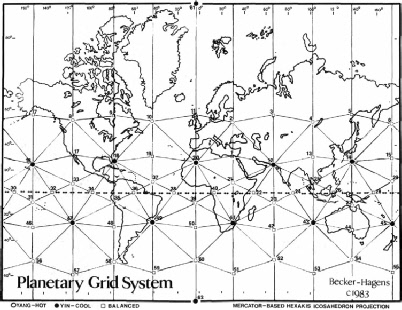
Yet we seem to have an accumulation of evidence as we discover ancient temples around the world seemingly located relative to one another over great distances, with an architecture that indicates an awareness of accurately marking both time and direction from the movements of the stars and the sun. Many temples also incorporate features that reflect knowledge of lunar phenomena such as eclipses.
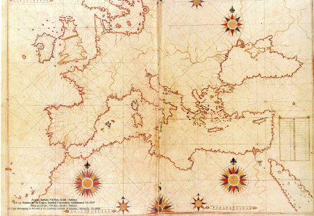
Maps such as the piri reis maps of the 15th century accurately depict coastlines of both Europe and the Americas based upon ancient maps. What challenges conventional wisdom is that these maps existed centuries before we developed the modern ability to map longitude.
Is the evidence simply coincidental, an accident and a myth? Or were our ancestors far more resourceful than we give them credit for today?
The Experiment
A few years ago Stonehenge Druid Frank Somers was working his way through observational
astronomy with the mind-
But why go to all the trouble of studying the moon, to the extent that eclipses could be predicted? What was the practical payback?
Frank did not believe that ancient astronomer priests the world over would go to these extraordinary lengths of observation and time keeping just to spoof a magic trick once every few years! ‘Look at me I have made the moon disappear!’. At the same time the problem of how they might have solved the longitude problem bothered him to the extent he couldn’t sleep at night until one day, after deciding to give the problem up entirely, he realised that the two problems were related. The Lunar eclipse is a tool necessary to solve the longitude issue.
He ran the idea past Sir Patrick Moore, a highly regarded British astronomer who agreed that this must have been how the ancients had solved the problem and urged Frank to conduct an experiment to prove it. Sadly, Sir Patrick passed away shortly after.
Ancient Tools required:
1. People : You and some friends to make the observation
2. A stone and some cord : essentially a plum line, a bit of string with a weight at one end.
3. A wooden compass and some chalk or charcoal to make a star map : We can use a pre printed version
4. Two or more accessible locations ideally many hundreds of miles apart from which to observe
5. Knowledge of the arrival of next suitable eclipse
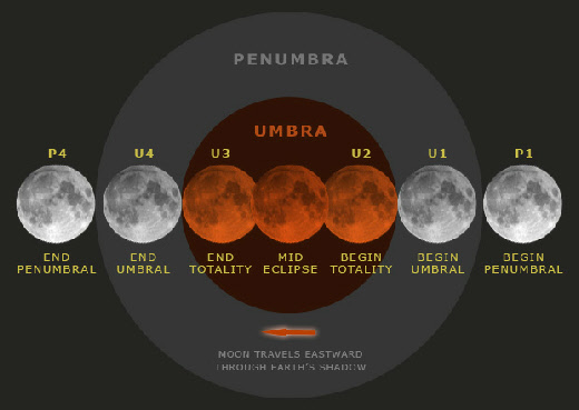
How the method works:
Everyone who has visibility of the moon when it goes into eclipse, sees the event start to happen at the same moment in time. This means that in that moment, if all observers were to look up at the sky following a plumb line, whatever position in the stars directly above could be marked on their charts. Then the charts would need to be labelled and returned to a common collection place, a journey maybe taking years. When two observations are plotted to the master chart, the relative location is known to both. For example if there were one observation made from the great pyramid at Giza, and this was plotted next to the observation made at Stonehenge, it would be known that Giza is located a set number of degrees southeast of Stonehenge and so many degrees distant. The relative latitudes and longitudes of the two sites are known.
Of course the sky moves on turning so the specific stars are of no further interest, but the distances and angles between sites can be plotted.and will not change. If thousands of people dispersed to observe the eclipse along the coast line of Europe, when their observations were combined, the shape of the map illustrated above would emerge.
Knowledge of the next suitable eclipse:
Where is it visible? If you are inside the area then you can take part!
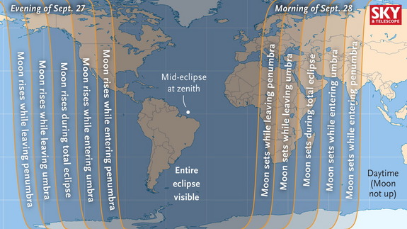
As with all lunar eclipses, the region of visibility for Sunday's blood-
What you will see:
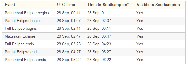
Note that locations east of Britain the local time will be later in the morning of 28th, check your timezone, and in the Americas it will be evening of the 27th, check your time zones!
Safety and disclaimer:
Please behave responsibly and put your safety first.
If you are venturing out, go with friends / adults, have appropriate clothing, a torch, a phone etc and do not venture to anywhere forbidden by law or to any place that might be for any other reason dangerous. Make sure people know where you have gone and when to expect you back safely.
We do not accept any responsibility or liability for loss or injury if you take part. By taking part you do so willingly of your own volition and entirely to volunteer in the spirit of human cooperation, and you accept that we have no liability.
If you take part, you accept that you do so in the spirit of friendly goodwill, and at your own risk and expense. We are not liable for, or offering to pay for the data gathered, or for your time or for your expenses.
Sorry, but in these modern times these things must be made clear.
Instructions:
Step 1. Get everything needed together:
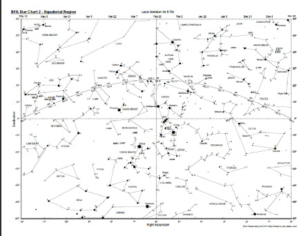
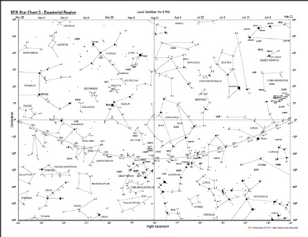
Download a copy of the star chart, we are using chart 2 and chart 3 to record the location you observe yourself to be directly beneath at the time you observe full eclipse begins (whole moon shaded & turning red).
We use free SFA charts downloadable from :
http://observe.phy.sfasu.edu/SFAStarCharts/SFAStarChartsAll.pdf
Write out a copy of these instructions
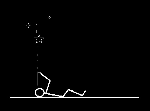
Make a plumb line, a bit of string with a small ‘non sharp’ weight, such as a cotton reel tied to one end. Just make sure when you are looking along it in the field it cannot hurt you.
A pen or pencil.
Step 2. Location
Check the weather conditions & if clear, go to location where sky overhead and moon are visible. Note, if cloudy you might decide to abandon the idea.
Step 3. Dry run
Before the moon eclipses it is a good idea to become familiar with the stars above you and practice with the plumb line and chart at relating what you see to the chart.
If you have a star either due north or due south of you, that will help locate the rough longitudinal region of the chart you are in (A compass or ground markers are a bonus...our ancestors build monuments with north south alignments)
Step 4. Watch the moon!
When the moon is fully shaded and starting to turn red, that is your que to hold your plumb line out, look up its length, compare the space above to the chart and make a mark on the chart as accurately as you can. You need to complete this within a couple of minutes to get really good results!
Step 5. Email us your results at science@stonehenge-
Include:
The country, region, nearest place to where you made the observation
The actual longitude / latitude from a map or mobile phone if available for that location.
The longitude degree (nominal) taken from your observation using simple methods
The latitude degree (actual) taken from your observation using simple methods.
The local time when you made your observation.
0
180
180
360
90
270
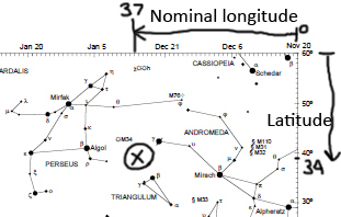
Made up example of position overhead marked onto a chart. Nominal Longitude uses the top most scale where 1 mark equals one degree. Count going right to left starting zero under Nov 20 on chart 2
X
When the plumb line is free to find its own true, if you look along it from the bottom, you are looking directly up.
Chart 2
Chart 3
This experiment has now taken place. Click here to view the results